Walking and Hiking in the Anti-Atlas
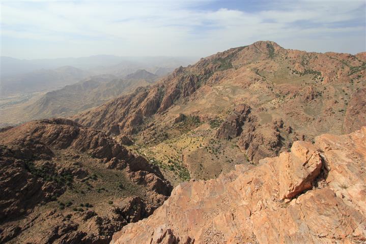
The Anti-Atlas mountains are a paradise for adventurous hill-walkers or trekkers, who can enjoy the region's stunning scenery and ancient villages from the network of Berber trails which criss-cross this rugged landscape. The huge potential of the area has not yet been fully developed, and Tafraout remains very much "off the beaten track" for tourists passing through Morocco. It does, however, have a rural charm and character that set it aside from the more popular trekking regions of the High Atlas, and holidays here will suit those who like a touch of adventure in their trip.
ACCOMMODATION
The Hotel Les Amandiers in Tafraout provides an ideal base for those wishing to explore the region. This superb 4-star hotel offers comfortable western luxury, favourable rates, and immaculate cleanliness, with excellent views across Tafraout and the Jebel el Kest Massif. More details can be found on our accommodation page.
GUIDES
There are no guidebooks at present, and maps can be very difficult to obtain... but this situation is slowly improving. The climbers' guidebook to the Ameln Valley (Climbing in the Moroccan Anti-Atlas by Claude Davies and Cicerone Press) contains some information for walkers including some recommended routes, though these are not described in much detail. A guidebook to the best walks in the Anti-Atlas is on the horizon, but won't be available for some time.
Many visitors to Tafraout will want to make use of local guides in order to explore the area, and these can easily be arranged on arrival in Tafraout. Hiring guides is the best option for those wishing to travel further afield, as jeep transport, pick-ups and visits or accommodation in local villages will all be arranged by the company. For local itineraries and custom treks in the Anti-Atlas, Trekking Tafraout are highly recommended.
some Recommended walks
Below are a suggestion of some walks that give a good introduction to the area:
Jebel el Kest
At 2359m above sea level, the main summit of Jebel el Kest is the highest peak in the Tafraout region, and its ascent is a popular challenge for enthusiastic hill-walkers. There are many options for ascent, although the two popular routes from the south side see almost all of the traffic. These are made either via Anergui (possible in one long day), or via Tagdicht, usually with an overnight stop. Both of these routes involve a large height-gain and some strenuous walking over rough terrain, for which maps are not readily available. It is usually to make the ascent in the company of a local guide, who can also arrange for overnight accommodation. For more information, see our new Jebel el Kest page.
A handy A4 map, showing the summit detail at 1:25k scale, as well as an overview of the whole range, is available in our Guidebook and Download Store
Adrar Mqorn
Meaning 'Big Mountain', Adrar Mgorn (or sometimes Mquorn) stands isolated some 8km to the south of Tafraoute and is another challenging objective for the hill-walker. Brief details of the ascent can be found in the Cicerone book "Climbing in the Moroccan Anti-Atlas".
The ascent of Adrar Mqorn is shown on OAC MiniMap Sheet 4
Adrar Idekel
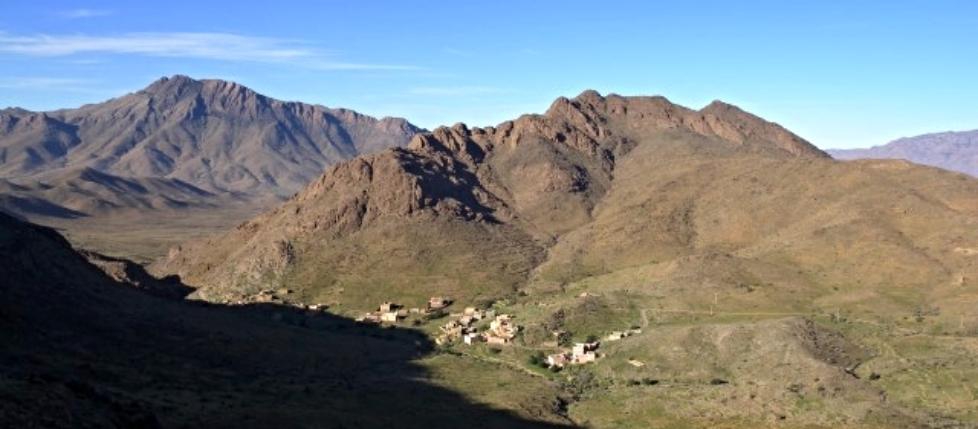
This comparatively short walk has a lot to offer, and is one of the better short-day walks to be had around Tafraout. Adrar Idekel lies above the tiny hamlet of Idekel, just to the west of the Tarakatine Pass, over which the main road runs into the Ameln Valley and Tafraoute. Probably the best way to the top is via the SE Ridge, which combines some first-class scrambling with memorable views of Jebel el Kest, the Ameln Valley and Adrar Mgorn.
The hamlet of Idekel is accessed along a narrow unsurfaced track which leaves the main road about half-way up the ascent to the Tarakatine Pass from the Ameln Valley. This turn-off is signposted in English. Park just before the village itself.
Traverse easy but pathless slopes above the village, heading for the obvious SE ridge. This is gained via a steep but simple ascent with some rock-bands to negotiate near the top. Once on the crest of the ridge the way is fairly obvious, and difficulties can be varied to suit your taste (avoidable scrambling up to grade 2). A number of steep towers can be taken direct with considerable interest, or circumnavigated via exposed traverses on which a head for heights is probably recommended. All of this, combined with some excellent views makes for a most enjoyable ascent, usually taking 1.5-2.5 hours. Not surprisingly the views from the summit are nothing short of spectacular.
Descent can then be made straight back towards the Idekel track via the easy terraced slopes on the NE side of the mountain.
A pdf download showing the route of this scramble is available here.
AMZKHSSAN SUMMITS
This is a very fine high-level circular walk which takes in some of the most impressive and important mountain faces above Amzkhssan, crosses some remote high passes, and features some of the best views you're likely to find in the range. Indeed, on a clear day it is possible to see all the way to Jebel Toubkal in the High Atlas over 200km away. The walk is mostly on ancient shepherd paths, and has significant cultural interest as well as awe-inspiring scenery. Some sections, however, are over pathless terrain and some care is required with route-finding. A full description (pdf download) of this highly-recommended walk can be found on our downloads page here.
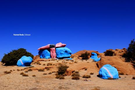
THE BLUE ROCKS FROM TAFRAOUT
The famous painted rocks of Agard Oudad are one of Tafraoute's 'must-see' attractions, and there's no finer way than on foot. This lovely half-day walk allows you to enjoy the Tafraoute back-country at your own pace, exploring the fascinating village of Agard Oudad, Napoleon's Hat, the Painted Rocks, and the ancient settlement of Tazekka, starting and finishing in the centre of Tafraoute. A pdf topo is available for download here.

Check out our complete range of local area maps, including the 1:50000 Outdoor Activity Maps as well as free downloads.