Climb Tafraout Blog
Miscellaneous ramblings, news, views, and anything else we fancied writing about...
Mapping the Anti-Atlas
August 2015
I'll never forget the first time we set foot in the Afantinzar Valley: we'd driven up beyond the Dwawj Slabs, on through Tagzene, and then over a high col without a name. Griffin Rock, Anammer, Ksar Rock, the Eagle Crags... none of them had yet seen the attentions of western climbers, but as we drove down the bumpy dirt road we knew had struck upon a paradise of adventurous trad climbing. Strangely, it was the striking arete of Park End, at Anammer Crags, that was the first route to catch our attention, though its first ascent would wait for another day. Our Ford Fiesta felt a very, very long way from the closest civilisation, and to add to the adventure we didn't even know in which direction that civilisation lay. In my mind, I was already piecing together a map of how we'd got here; and more importantly, how we were going to get out at the end of the day.
In the event, we never did get out of Afantinzar that day, but that's a different story. Over the next few years we pieced together more of the puzzle; new valleys and new crags were opened up each season. Tagzene, Tagmout, Samazar, and the Takoucht Escarpment all became major centres for climbing in the area, and more recently explorations along the Aouguenz Road and into the Amaghouz Gorge have provided dozens of Anti-Atlas climbers with that same, incredible sense of adventure. Along the way, we hunted high and low for decent maps of the area, hoping they would reveal the next 'Afantinzar' without all the effort of mapping it ourselves. But no such luck, and so it was that we started drawing maps...
2007
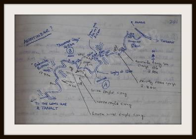
This was the first map of Afantinzar to appear in the Tafraout Livre d'Escalade in the Amandiers Hotel. Up to this point, the only climbing on the north side had been to Asseldrar (by the original Ameln pioneers, based out of Ait Baha) and the Dwawj Slabs (by Geoff Hornby and team). The name "Afantinzar" (written here with a question mark) was coined from the map in the lobby of the Amandiers hotel, which was the main source of information for accessing the north side in 2007.
2008
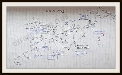
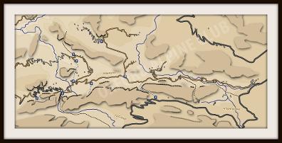
Within a year of the first climbs being put up in Afantinzar and Tagzene most of the Afantinzar crags had been climbed and named by western climbers. This updated map in the Livre d'Escalade provided an 'index' for the vast number of new lines now being recorded on these newly named crags. The first forays into Samazar had only just taken place, but the name "Samazar" had already caught on despite being a mis-remembering of "Tamza".
2009
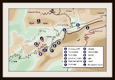
The first work started on a guidebook to the north side of Jebel el Kest, originally in the form of an online web guide. This was the map of Samazar at the time, drawn pretty much from memory and not to scale.
2010
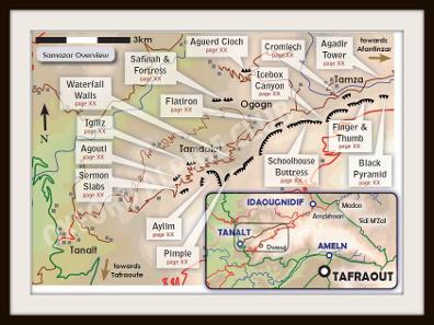
The publication of the "Moroccan Anti-Atlas North" guidebook necessitated better mapping. The main access routes to all the climbing areas were, by now, well understood and drawn accurately to scale. Relief information in this map is still an approximation.
2012
Another new guidebook... and updated mapping. Roads, rivers, and even individual buildings are all correctly illustrated thanks to publicly available data on Google Earth, though terrain data is still a manually drawn approximation. This particular image was a "work-in-progress" for the new guidebook, before the labels were added!
2015
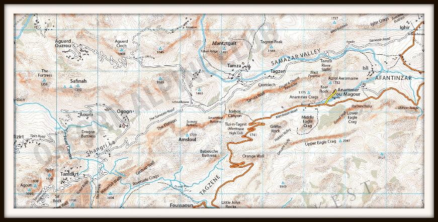
One of the last missions of the Space Shuttle was the "Shuttle Radar Topography Mission" which gathered elevation data for the whole planet. Whilst we were all out in the sunshine, boffins at the Consortium for Spacial Information and USGS were writing some very clever algorithms to analyse a mind-boggling amount of data. Today, it allows us to draw accurate relief maps of the Anti-Atlas, such as this sample from Afantinzar and Samazar.
It may take quite a while for exciting (yes, I am a sad map obsessive) data like this to have an impact on climbing in the Anti-Atlas, but perhaps the days of Tafraout's reputation as being a place where 'you're guaranteed to get lost' are numbered...
You can see some of the production in the video below... including digitizing the roads, rivers, buildings and crags....